updated
1 year ago

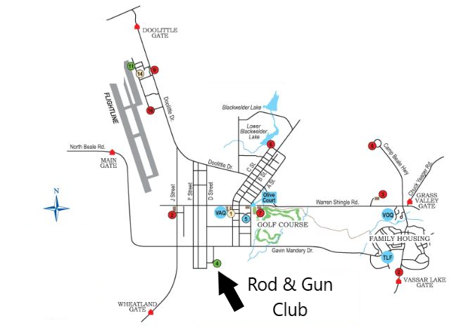
From Marysville to Main Gate (Snider Gate), then to
Beale Rod & Gun Club.
Go South on Highway 65. As soon as you cross the E
street bridge, take exit to North Beale Road. Follow
North Beale Road to Main Gate (turn left at Costco,
go through Linda, go past Yuba College, go past
Museum of Forgotten Warriors. Road goes directly to
Snider Gate. Once through the gate, proceed around
the runway. At 4 way stop sign, go straight. Over
Railroad tracks, second exit to the right (D
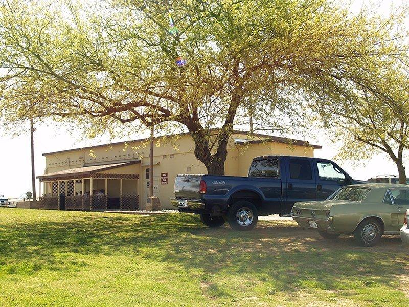
street), Building on hill, next to cell tower. Park
next to one of the trees.
From Marysville to Doolittle Gate, then to Beale Rod
& Gun Club.
Go East on Highway 20, and at Ramirez Street traffic
light turn South. At Rameriz Street and Simpson
Lane, travel southeast over levee. Follow Simpson
lane past racetrack and turn east (left) on to
Hammonton Smartsville Road. Past Teichert Aggregates
(on left) as you climb the hill, the gate is to the
right. Once through the gate, follow Doolittle drive
past the flight line and fire station on right. Just
past fire station, road comes to a “Y.” Veer right
onto J Street. Go past gas station on your right. At
four way stop (J and Gavin Mandry, LED Screen sign
on your left), turn east (left). Over Railroad
tracks, second exit to the right (D street),
Building on hill, next to cell tower. Park next to
one of the trees.
From Marysville to Wheatland Gate, then to Beale Rod
& Gun Club.
Go South on Highway 65. At the “Y” of 70 & 65,
continue on Highway 65. Take the exit ramp to 40
mile road/Ostrum road (Casino exit). Turn left (go
east) from the exit ramp, and cross over Highway 65.
At stop sign, go straight. Go over railroad tracks,
traveling east on Ostrom, go straight at four way
stop sign (Virgina and Ostrom). Continue east. At
four way stop sign (south Beale Road and Ostrom)
turn left (north) to Wheatland Gate. Once through
the gate, travel north to 4 way stop sign
(intersection with big LED sign). Turn right (east),
over Railroad tracks, second exit to the right (D
street), Building on hill, next to cell tower. Park
next to one of the trees.
From Grass Valley to Grass Valley Gate, then to
Beale Rod & Gun Club.
Go West on Highway 20, then turn onto
Hammington/Smartsville Raod (next to Dollar
General). Couple of miles down, turn left onto Chuck
Yeager Road. Follow Chuck Yeager Road to Grass
Valley Gate. (If you accidently turn onto Waldo
Road, you will see the Spenceville Firing Range on
your left). Once through the gate, proceed to
intersection. Turn right onto North Beale Road
(might also be shown as Warren Shingle Road). At
stop sign of A and Warren Shingle (next to SR71
Aircraft display on right), turn Left on A Street. A
street ends at Gavin Mandry Drive (might also be
listed as 6
th
street). Turn right on Gavin Mandry Drive. Rod and
Gun is first left exit (D street), Building on the
hill, next to cell tower. Park next to one of the
trees.
From Grass Valley to Doolittle Gate, then to Beale
Rod & Gun Club.
Go West on Highway 20, then turn onto
Hammington/Smartsville Raod (next to Dollar
General). Follow Hammington/Smartsville Road to
Doolittle Gate on left. Its at the top of one of the
rises in the road. Once through the gate, follow
Doolittle drive past the flight line and fire
station on right. Just past fire station, road comes
to a “Y.” Veer right onto J Street. Go past gas
station on your right. At four way stop (J and Gavin
Mandry, LED Screen sign on your left), turn east
(left). Over Railroad tracks, second exit to the
right (D street), Building on hill, next to cell
tower. Park next to one of the trees.
From Grass Valley to Snider Gate (Main Gate), then
to Beale Rod & Gun Club.
Go West on Highway 20, then turn onto
Hammington/Smartsville Raod (next to Dollar
General). Follow Hammington/Smartsville Road down
past Beale AFB. Once you pass all the high power
transmission line, you will turn left (south) onto
Brophy road. Continue on Brophy road until it ends
at North Beale Road. Turn left (East) onto North
Beale road, go past Museum of Forgotten Warriors.
Road goes directly to Snider Gate. Once through the
gate, proceed around the runway. At 4 way stop sign,
go straight. Over Railroad tracks, second exit to
the right (D street), Building on hill, next to cell
tower. Park next to one of the trees.
From Plumas Lake to Wheatland Gate, then to Beale
Rod & Gun Club.
Take Plumas Arboga Road to 40 mile/Ostrom Road. Go
past Amphitheater, Go Past Casino, cross over
highway 65. At stop sign, go straight. Go over
railroad tracks, traveling east on Ostrom, go
straight at four way stop sign (Virgina and Ostrom).
Continue east. At four way stop sign (south Beale
Road and Ostrom) turn left (north) to Wheatland
Gate. Once through the gate, travel north to 4 way
stop sign (intersection with big LED sign). Turn
right (east), over Railroad tracks, second exit to
the right (D street), Building on hill, next to cell
tower. Park next to one of the trees.
From Wheatland to Wheatland Gate, then to Beale Rod
& Gun Club.
Travel North on Highway 65. As soon as highway
splits into a divided highway, exit to the right
onto South Beale Road. Cross over railroad tracks,
follow South Beale Road to Wheatland gate. Once
through the gate, travel north to 4 way stop sign
(intersection with big LED sign). Turn right (east),
over Railroad tracks, second exit to the right (D
street), Building on hill, next to cell tower. Park
next to one of the trees.
From Wheatland to Vassar Lake Gate, then to Beale
Rod & Gun Club.
From Wheatland, travel East on Spenceville road,
cross over railroad tracks, travel east past Big
Al’s Market. Continue East onto Camp Beale Highway
(may also continue as Spenceville road). Road takes
a bend to the left (Camp Far West Road goes to the
right), continue to Vassar Lake Gate. Once through
the gate, go past Subway & gas station. Turn
left (west) onto 6
th
street (Wheatland Charter Academy on your right).
Travel through housing, go over 3 river bridges
(road becomes Gavin Mandry Drive). . Rod and Gun is
first left exit (D street), Building on the hill,
next to cell tower. Park next to one of the trees.
From Wheatland to Snider Gate (Main Gate), then to
Beale Rod & Gun Club.
From Wheatland, go North on Highway 65. After
Highway 70 and 65 join, exit off on Erle Road. Turn
right (East) on Erle Road. At the stop sign (end of
all the housing on left) of Griffith Ave and Erle
Road, turn left (north). After a short distance on
Griffith Ave, turn right (east) at stop sign of
Griffith and North Beale Road. Road goes directly to
Snider Gate. Once through the gate, proceed around
the runway. At 4 way stop sign, go straight. Over
Railroad tracks, second exit to the right (D
street), Building on hill, next to cell tower. Park
next to one of the trees.


